


04 Finiels-Florac

nicolas54230
User
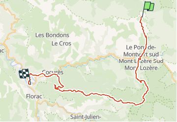

Length
32 km

Max alt
1421 m

Uphill gradient
831 m
Km-Effort
45 km

Min alt
539 m

Downhill gradient
1509 m
Boucle
No
Creation date :
2019-01-15 12:32:49.481
Updated on :
2019-01-15 12:32:49.481
2h47
Difficulty : Difficult

FREE GPS app for hiking
 SityTrail
IGN / Geographical institutes
SityTrail Plus
The world is yours!
About
Trail Mountain bike of 32 km to be discovered at Occitania, Lozère, Pont de Montvert - Sud Mont Lozère. This trail is proposed by nicolas54230.
Positioning
Country:
France
Region :
Occitania
Department/Province :
Lozère
Municipality :
Pont de Montvert - Sud Mont Lozère
Location:
Le Pont-de-Montvert
Start:(Dec)
Start:(UTM)
559388 ; 4917018 (31T) N.
Comments